
- Contents
On the evening of 24 June 2026, a magnitude 7.2 foreshock struck north-central Venezuela and, 39 seconds later, a magnitude 7.5 mainshock followed. Both were shallow. Destruction concentrated in the coastal state of La Guaira and the capital, Caracas, where La Guaira was declared a disaster zone. GeoPoll reached affected households directly through a WhatsApp rapid needs assessment that opened the morning after the quake and remains in the field.
This report updates our first assessment, published on 28 June. The larger sample widens geographic coverage across the country and lets us separate the areas in crisis from those that felt only a tremor with far greater confidence.
Summary Findings
- The impact is concentrated, and the pattern held as the sample grew. Six states along the central coast and capital corridor account for 432 of 846 responses. La Guaira (average felt intensity 9.6 out of 10), Caracas (8.8), Miranda (8.4), Carabobo (8.3) and Aragua (8.3) remain the core of the disaster. Yaracuy (7.4) emerged as a newly prominent high-intensity state in the larger sample.
- Quake-driven needs cluster sharply in the impact zone. Housing damage, displacement, loss of drinking water, blocked roads and compromised hospitals are two to three times more common inside the zone than outside it.
- Food, power and connectivity gaps appear nationwide. Limited food (51 percent in the zone, 45 percent outside), unreliable electricity and patchy connectivity are elevated everywhere, pointing to pre-existing strain the earthquake compounds rather than causes. Distinguishing the two matters for targeting.
- Water and food are the binding constraints in the zone. 41 percent of impact-zone households report limited or no drinking water and 51 percent limited or no food. Food was the single most requested need in open responses, named by roughly 293 households nationwide.
- Displacement is real but a minority. In the impact zone, 81 households (19 percent) will not sleep in their own home, including 17 sleeping outdoors or in the street.
- The information gap persists. Nationwide, 58 percent said the information they most need but cannot get is aftershock and safety updates, and nearly four in five rely on social media or WhatsApp for earthquake information.
- Respondents skew older and urban. The mean respondent age is 53 and 59 percent live in urban areas. This shapes interpretation and is discussed in the methodology note.
Background and method
The emergency
The 24 June sequence was felt most violently along the north-central coast and in Caracas. Authorities declared La Guaira a disaster zone and reported that more than 70,000 families were affected. Official casualty figures, which remain the authoritative source for loss of life, ranged as of late June from roughly 188 to 235 dead and more than 4,300 injured, with numbers expected to rise as assessment continued.
GeoPoll fielded a rapid needs assessment via WhatsApp, reaching people on the phones already in their hands and allowing them to report their own conditions. The instrument covers 54 questions spanning location, felt intensity, household casualties, housing, displacement, water, food, power, connectivity, roads, hospital access, gas and fire risk, information needs and sources, and demographics.
Finding 1: The impact is geographically concentrated
When we map self-reported shaking intensity by state, a clear cluster emerges along the north-central coast and capital corridor, matching the areas authorities and humanitarian agencies identified as worst affected. We define the impact zone as six states, consistent with our first report, so the two rounds can be compared directly.

The six-state impact zone accounts for 432 of 846 responses, roughly 51 percent of the sample. La Guaira, which residents rated the most severe, is where authorities declared a disaster zone. The independent, household-level data points to the same epicenter of suffering that official channels identified, which raises confidence in both.
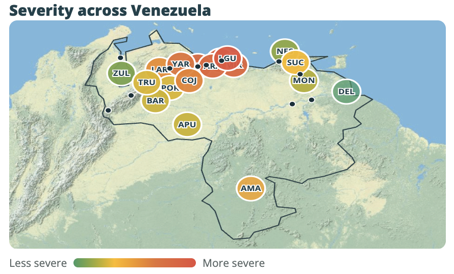
The contrast at the bottom of the chart is the actionable part. Need is concentrated, not diffuse. Resources directed to the central coast and capital region will reach the people in crisis. Broad national distribution would spread thin across areas that report little damage.
Finding 2: Inside the impact zone, what households face
The larger sample allows a comparison the first report could not make cleanly: conditions inside the impact zone against a substantial rest-of-country sample. That comparison separates the needs the earthquake created from the strain Venezuelan households were already living with. Both are real. They call for different responses.

Quake-driven: housing, displacement, water and access
Inside the impact zone, 60 percent of households report home damage, including 28 with major damage, unsafe conditions or a home destroyed. Across the rest of the country combined, only 9 households reported major damage or destruction. Displacement follows the same line: 81 impact-zone households (19 percent) will not sleep in their own home, of whom 52 are staying with relatives or neighbors and 17 are sleeping outdoors or in the street, mirroring what responders report in Caracas and La Guaira, where residents fear weakened buildings could collapse in an aftershock.
Water shows the same quake signature. In the impact zone, 31 households report no drinking water and 146 only limited water, 41 percent constrained against 23 percent outside the zone. Caracas alone accounts for 15 households with no water and 53 with limited supply. Blocked roads and damaged or unreachable hospitals also concentrate in the zone, at 40 and 38 households respectively.
Nationwide strain: food, power, connectivity
Food scarcity is worst in the zone (51 percent limited or none) but high everywhere (45 percent outside), and electricity problems are actually more common outside the zone (38 percent against 30 percent), led by chronically affected states such as Zulia. These are largely pre-existing national conditions the earthquake compounds locally. Zone targeting addresses the quake damage; only broader programming addresses the baseline strain.
Finding 3: The human toll, in the words of those reporting it
Each figure below is a household that reached out. These are counts of respondents reporting an emergency in their own household, not population totals. Trapped-person reports concentrate almost entirely in the impact zone: 25 of the 28 come from inside it.

Some households also reported a death in the family. Consistent with the principle stated in the graphic, we do not publish a casualty count and defer to official figures. These reports do, however, signal where bereavement support and family tracing are most needed, concentrated in the impact zone.
Behind each figure is a voice. Respondents were asked, in one or two words, what their household needs most. Their answers, published anonymously and without editing, carry the assessment better than any aggregate.
“Que los saquen de los escombros, necesitamos maquinarias y voluntarios”Caracas; home destroyed, family in La Guaira, relatives missing
“Mi hijo es militar y está en La Guaira y no me he comunicado con él desde las 11 de la mañana”Caracas
“Agua potable y comida con urgencia”La Guaira; household displaced, no water
“Que aparezca mi hermano”Trujillo; family member missing
“Enlatados, agua, pasta de dientes, jabón, bombillos recargables, velas”La Guaira; sheltering, home damaged
“Ayuda psicológica y comida”Miranda
Many respondents whose own homes were intact used the same open text to point responders elsewhere, writing that others nearby had lost more. That instinct is worth noting for coordination: community members are themselves flagging where the deepest need sits.
Finding 4: The information environment and what people cannot find out
Disruptions to power and telecommunications, in an already limited information environment, have made it hard for residents and their relatives to learn what has happened. The assessment measured both what information households most need and where they are getting it.

Aftershock and safety information dominates every other need by a wide margin, inside and outside the impact zone alike. People are not only short on water and shelter, they are short on the knowledge they need to decide whether to sleep inside, when to return, and how to stay safe if the ground shakes again.
The channel data explains why the gap persists and what to do about it. Households rely overwhelmingly on informal digital channels rather than official broadcasts. If nearly four in five people get earthquake information from social media and WhatsApp, then official aftershock guidance, return-safety advice and shelter information will reach them fastest through those same channels. A WhatsApp assessment like this one is not only a listening tool. It is a demonstrated delivery channel for the exact safety information households say they cannot get.
Finding 5: What people say they need most
Beyond the structured indicators, households described their most pressing need in their own words. Coding those open responses into themes gives a demand-side view of priorities that closed questions cannot.

Three points stand out for responders. First, food has overtaken water as the most frequently named need in this larger sample, though both remain acute and often appear together in the same response. Second, psychological support recurs often and explicitly, with dozens of households asking for calm, reassurance or mental health help, an easily overlooked need in the first days after a quake. Third, many households frame their need economically, asking for the means to buy food and materials rather than the items themselves, which is relevant to any cash-based response design
Implications for the response
The assessment points to a clear, sector-linked set of priorities for the central coast and capital region.
- Target geographically. Concentrate water, shelter and repair response on La Guaira, Caracas, Miranda, Carabobo, Aragua and Yaracuy. The data does not support thin national distribution for quake-driven needs.
- Lead with water and food. Roughly half of impact-zone households report constrained food and four in ten constrained water. These are the binding daily constraints and the top open-text asks.
- Distinguish quake damage from chronic strain. Housing, displacement, water and access problems are quake-specific and zone-targeted. Food, power and connectivity gaps are national; programming for them should not assume they end at the zone boundary.
- Design for cash where markets function. Many households ask for the means to buy essentials, suggesting cash or voucher modalities can work alongside in-kind distribution.
- Resource medical outreach and family tracing in the zone. Trapped-person, injury, missing-person and damaged-hospital reports cluster almost entirely in the impact zone.
- Include mental health and psychosocial support. Requests for calm and psychological help are frequent and explicit.
- Deliver safety information through social media and WhatsApp. That is where nearly four in five households already get earthquake information, and aftershock and return-safety guidance is the single most requested unmet need.
Data access and how GeoPoll can help
GeoPoll specializes in reaching people that other data collection methods miss, gathering direct household input from hard-to-reach and crisis-affected populations across emerging markets, fast. This assessment was fielded over WhatsApp and reached hundreds of households within hours of launch.
We are sharing this assessment and the live dashboard openly with the relief and aid community. The dashboard lets responders filter by state and explore each indicator in detail, and it continues to update as more responses arrive. The full dataset can be broken down by state, municipality, indicator or population group to match what a given response requires. GeoPoll can also field follow-up questions to the same households or launch a new rapid assessment within hours.
- Live dashboard: surveys.geopoll.com/art/venezuela-earthquake
- First report: geopoll.com/blog/venezuela-earthquake-report
- Contact: geopoll.com/contact-us
Methodology note
Mode: WhatsApp self-completion survey. Field period: 25 June to 11 July 2026, ongoing. Completed responses in this report: 846. Instrument: 54 questions in Spanish covering location, felt intensity, household casualties, housing, displacement, water, food, power, connectivity, roads, hospital access, gas and fire risk, information needs and sources, and demographics.
Analysis: Figures are unweighted counts and percentages of respondents. Felt intensity is self-reported on a 1 to 10 scale; 833 of 846 respondents gave a numeric rating. The impact zone comprises La Guaira, Capital District (Caracas), Carabobo, Miranda, Aragua and Guárico, defined for consistency with the first report. Urgent-medical need was asked only of households reporting an injury. A small number of open-ended fields were coded into themes for the needs analysis. All charts in this report are generated directly from the response data.
Limitations: The sample is self-selected and opt-in, unweighted, skews older and urban, and broadened in composition as outreach expanded. Households in the worst-hit areas without power, signal or a working phone are underrepresented, so severe conditions are more likely understated than overstated. These data complement, and do not replace, official damage and casualty figures.
Ethics: Responses were collected anonymously. Quotes are published without identifying information. GeoPoll does not publish its own casualty figures and defers to official sources for loss of life. GeoPoll participates in IRB processes and is a member of ESOMAR, WAPOR, PAMRO and the Society for International Development.